What’s Happening?
Redland City Council will conduct a hazard reduction burn within the Bayview Conservation Area, weather conditions permitting.
Council’s Parks and Conservation Crews will manage the burn across selected bushland sections under controlled conditions.
Why It Matters
The burn will reduce forest litter that can fuel bushfires and increase danger across surrounding areas.
It will also create conditions that support native plant regeneration within the conservation area.
Local Impact
Traffic controls and smoke hazard signs will be available if smoke affects nearby streets.
Motorists should drive carefully and adjust their speed and behaviour to the conditions.
Council recommends that nearby residents close windows and doors while smoke is present. People with respiratory conditions should keep medications nearby.
By the Numbers
- The planned burn is scheduled across two days, Thursday 30 and Friday 31 July 2026, subject to suitable weather.
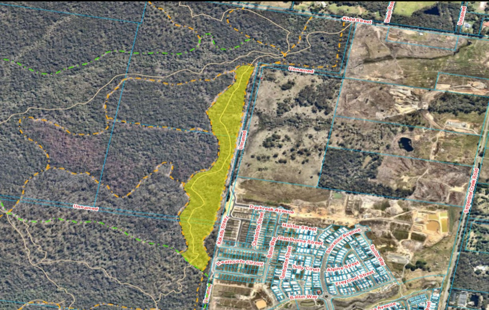
- The burn area covers sections near 76–152 Kidd Street, Redland Bay, marked in yellow on Council’s map.
- Council follows six wildlife protection measures, covering habitat exclusions, site inspections, patchy burns and safe movement corridors.
Zoom In
Council aims to protect wildlife by using cooler, slower and less intense burns with lower flames.
Sensitive wildlife habitat is excluded from planned burn areas. Crews also burn vegetation in a mosaic pattern, leaving unburnt patches.
Before each burn, crews inspect the site for wildlife and clear areas around hollow-bearing trees and important habitat features.
Staff walk through the site during preparation in the days before the burn. They complete another inspection on the day.
Crews also try to maintain safe corridors for wildlife that may temporarily move away from the burn area.
Zoom Out
Residents can register for targeted alerts about planned burns on Council land. Notifications consider the burn location and prevailing winds.
Registration is available through the Redlands Coast Disaster Dashboard under the Redlands Coast Alerts tab.
Further details about Council’s program are available on the planned burns webpage.
What To Look For Next?
The burn will proceed on 30 and 31 July if weather conditions remain suitable.
Nearby residents may notice smoke, traffic controls and advisory signs while crews complete the work.